About Polaris GPS Navigation
Easy-to-use high performance GPS for wherever your travels take you. No account setup or subscriptions required. Turn your phone into a powerful GPS navigation system with Polaris Navigation GPS, the most accurate...
Easy-to-use high performance GPS for wherever your travels take you. No account setup or subscriptions required.
Turn your phone into a powerful GPS navigation system with Polaris Navigation GPS, the most accurate all-purpose GPS, and dare to go where there are no roads.
Imagine... What would it be like to navigate any waterway or hike any wilderness or city using only your phone's GPS location abilities and a view of the sky? What it would be like to create navigation destinations without the need of an internet connection and find them using offline maps or a waypoint pointing arrow.
That is just a glimpse of the navigational power you will hold in your hands when you install Polaris Navigation GPS.
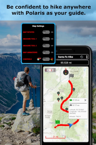
Used mostly as a hiking, off road, nautical and trail GPS app, Polaris is an excellent backup or replacement for your dedicated GPS satellite navigation unit and will keep you oriented wherever your outdoor adventures take you!
Typical usage:
● Waypoint navigation.
● Hiking GPS with the best hiking maps! Search and find nearby trails.
● Back country exploration and outdoor adventure.
● Record tracks and navigate trails.
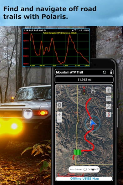
● Offroad navigation support for your ATV, Jeep or other 4x4 vehicle.
● Sailing / Boating. All marine navigation charts in Polaris are free.
● Fishing GPS. Easily find you favorite fishing hole.
● Hunting and hunting maps. Find you favorite hunting blind and your way back!
● Geocache
● Camping
● Mountain Biking and bike maps
● Backpacking and other outdoor sports
● Compass orienteering
Known for its
stability, reliability and flexibility , Polaris is used by land-sea search and rescue, military personnel and millions of others worldwide.
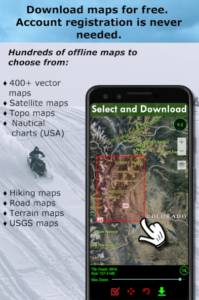
For your offline adventures we provide:
📡
Unlimited free access to our offline vector & raster maps (topographic maps, marine, hiking and others).
📡 Offline nautical charts for the USA included (ENC's and raster).
This powerful navigation system also includes:
📡 Polaris Places Picker. Find hiking trails, camping locations and much more!
📡 GPS compass and magnetic compass.
📡 GPS info panel.
📡 Odometers, altimeters, speedometers, chronometers.
📡 Split distances on tracks.
📡 Connect your waypoints and navigate the track they define.
Map Types:
- Google Maps
- OpenStreetMap-Mapnik
- Topographic Maps
- Cycle Route and Hiking Maps
- Vector Maps
- USGS Topo
- NOAA Marine Charts
- Aviation Operations Charts
- Canada Toporama
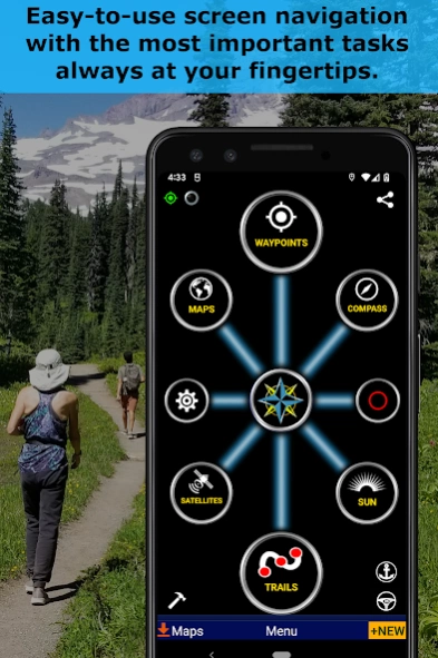
📡 Comprehensive set of GPS Tools and diagnostics.
📡 Waypoint navigation system including a dynamic waypoint-finding compass that always points to your destination while reporting estimated time of arrival, distance to target and other statistics. Just follow the arrow!
📡 Trail navigation system
📡 Altitude profiles
📡 Location sharing
📡 Supports British OSGR and OSGB-36 DATUM (Ordnance Survey Grid).
📡 Coordinate formats: latitude/longitude as degrees, deg:min, deg:min:sec, and UTM (Universal Transverse Mercator)
📡 Military Coordinate Finder - Military Grid Coordinate Reference System (MGRS)
📡 Hiking Trails - Most of the maps show hiking paths courtesy of the Openstreetmap project. You will find that even some of the most remote hiking routes are visible on our maps.
⚓ Marine navigation- NOAA Nautical Charts and nautical unit reporting.
⚓ Drift alert / Drag anchor alarm.
📡 Select source for altitude reporting: Satellites, United States Geologic Survey or map your location to the results of NASA's Space Shuttle Radar Topography Mission.
📡 Waypoint photos stamped with coordinates.
📡 Road navigation and street directions are provided through a digital pipeline connecting the power of Polaris to the Google Maps app on your device.
* The premium version of Polaris Navigation is called GPS Waypoints Navigator, available on Google Play. GPS Waypoints Navigator is ad-free and contains many other enhancements .
Previous Versions
Here you can find the changelog of Polaris GPS Navigation since it was posted on our website on 2014-06-14 02:35:47.
The latest version is 9.25 and it was updated on 2024-04-23 10:13:33. See below the changes in each version.
Polaris GPS Navigation version 9.25
Updated At: 2024-01-30
Changes: 1. Find hiking and bike trails in your area or around any location.
Polaris GPS Navigation version 9.24
Updated At: 2023-09-29
Changes: 1. New features and themes, improvements and bug fixes.
Polaris GPS Navigation version 9.23
Updated At: 2022-03-19
Changes: 1. New maps: Hiking and biking, National Geographic and others.
2. The Map It companion app is no longer required for location and waypoint searches.
3. Added boundaries and place labels to offline satellite maps so they are easier to use.
Polaris GPS Navigation version 9.22
Updated At: 2021-12-20
Changes: 1. Unlocked more waypoints and trails.
2. Energy optimizations: Uses less battery when connecting to internet for online services.
3. Minor bug fixes and optimizations.
Polaris GPS Navigation version 9.21
Updated At: 2021-09-29
Changes: 1. Bug fixes.
2. Improved support for external mbtiles map files.
3. Added Nautical Electronic Navigation Charts (ENC's for USA only). Older raster nautical charts are still available.
4. The most recent Android security features have been added.
Polaris GPS Navigation version 9.19
Updated At: 2021-09-23
Changes: 1. Improved support for external mbtiles map files.
2. Added Nautical Electronic Navigation Charts (ENC's for USA only). Older raster nautical charts are still available.
3. The most recent Android security features have been added.
Polaris GPS Navigation version 9.18
Updated At: 2021-02-09
Changes: Lots new in this release:
1) Updated map engines: Maps run faster, smoother and offer more features.
2) Vector maps updated to reflect the latest geographic information.
3) All maps may now operate in heading-up or north-up mode, controlled either by GPS or magnetically.
4) Gyroscopic stabilization added to all magnetic compasses.
5) Graphics and UI improvements.
Polaris GPS Navigation version 9.16
Updated At: 2020-11-10
Changes: 1. New navigation satellite identification and locations map.
Polaris GPS Navigation version 9.15
Updated At: 2020-08-10
Changes: 1. This is a critical update for NOAA Nautical Charts USA.
2. Efficiency improvements for raster map viewing and downloading.
Polaris GPS Navigation version 9.14
Updated At: 2020-08-04
Changes: Security improvements.
Optimizations for Android 9 and 10.
Disclaimer
Official Google Play Link
We do not host Polaris GPS Navigation on our servers. We did not scan it for viruses, adware, spyware or other type of malware. This app is hosted by Google and passed their terms and conditions to be listed there. We recommend caution when installing it.
The Google Play link for Polaris GPS Navigation is provided to you by apps112.com without any warranties, representations or guarantees of any kind, so access it at your own risk.
If you have questions regarding this particular app contact the publisher directly. For questions about the functionalities of apps112.com contact us.